
Archive Record
Images
Metadata
Title |
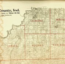
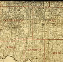
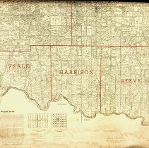
1939 "Farm Ownership" wall map of Daviess County |
Object Name |
Map |
Catalog Number |
2021.FIC.0732.0013 |
People |
Beckett, John M. Billings, Jesse F. Capehart, Homer E. Carnahan, Helen Carnahan, Margaret Clark, Jacob Cosgrove, William P. Dillard, John W. Donaldson, Frank M. Graham, Robert C., Sr. Howard, Anne E. Keith, Troy Keith, Willard Lucas, Julia Morris, Adelah Mumaw, John A. Reeves. Samuel T. Ryan, John W. Stalcup, Stella Swann, Clara Wichman, Henry Wright, Stella |
Date |
1939 |
Scope & Content |
Two copies of a 1939 "Farm Ownership" wall map (3 x 4 feet) of Daviess County, Indiana. In each township there are notations of the land owners and the amount of their acreage. The names noted in the People Field are a small fraction of the individuals and businesses referenced on this map. See 2021.FIC.0732.0012 for the same 1939 "Farm Ownership" map with business ads. |
Collection |
Map & Chart Collection |