
Archive Record
Images
Metadata
Title |
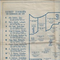
1936 map with county vote totals for Gubernatorial election |
Object Name |
Map |
Catalog Number |
2018.FIC.5006 |
People |
Smiley, Paul G. Springer, Raymond Townsend, M. Clifford |
Date |
1936 |
Scope & Content |
Map printed by Indiana Highway Department showing vote totals in each county for the 1936 Gubernatorial election between M. Clifford Townsend, Democrat, and Raymond Springer, Republican. Mr. Townsend won handily and carried Daviess County by a majority of 123 votes. |