
Archive Record
Images
Metadata
Title |
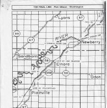
Map of Wabash and Erie Canal in Daviess County |
Object Name |
Map |
Catalog Number |
2018.FIC.4629.0002 |
People |
McGuire, Rosemary E. Schmidt, Carolyn |
Date |
2007 |
Scope & Content |
Map of the Wabash and Erie Canal in Daviess County, Indiana that was included in a April 25, 2007 letter from the Canal Society of Indiana (CSI) in Fort Wayne, Indiana to the Daviess County Historical Society (See 2018.FIC.4629.0001). CSI is a not-for-profit corporation with a mission to preserve the bed and structural remains of the Indiana canal system built in the early 19th century. The Wabash and Erie Canal operated in Daviess County from 1853 to 1860. The map showed the route of the canal from Newberry, Indiana to Maysville, Indiana (just west of Washington) and the location of canal locks and one aqueduct. |
Search Terms |
Canal Society of Indiana Daviess County Historical Society Wabash & Erie Canal |